Introduction to 2 & 3D Drone Modeling With Agisoft Metashape
- Description
- Curriculum
- FAQ
- Reviews

This course covers 2D & 3D Modeling with DJI drones and Agisoft’s Metashape. In this class students will learn about capturing images with their DJI drones for creating models. Students will then walk through the process of generating 2D & 3D models with a software package known as Metashape, developed by Agisoft.
The basic principles of Drone Modeling will be covered in this course. Capture images, import to a modeling program, aligning images, generating a point cloud, generating a 3D mesh, and generating a texture file. Most programs for drone modeling follow this workflow. So even if you’re not a Metashape user, this class will still walk you through the basics of the modeling process.
A fair amount of the course will cover capturing drone images for 2D & 3D Models. We introduce several capture applications and show flight setups for creating models. If your initial flights aren’t good, your model will most likely turn out poorly as well. So focusing on initial image captures is very important in this course.
We will introduce Metashape Standard Edition and Pro Edition for your modeling process. While other programs allow you to achieve similar results, their interfaces vary from program to program. Metashape is easy enough for beginners to work with, and powerful enough for professional drone modeling applications as well.
Ground Control Points and Advanced Modeling Topics
This course on drone modeling with Agisoft’s Metashape is designed for beginners who are interested in generating 2D & 3D Models. While the course gives a brief over view of manual image alignment and Ground Control Points, it does not get into the great detail and complexity of utilizing Ground Control Points (GCPs). If you’re approaching the professional level of drone modeling you will require a more advanced class than this one.
Pilot in Command’s Responsibilities
In this course we’ll be discussing a lot of automated drone flight. If you’re intending on using a drone for the purposes of mapping and modeling you should have a basic understanding of your drone, the rules and regulations where you’re flying, and your personal responsibility as a drone pilot. This course does not cover basic drone flight principles nor flight regulations, and it’s up to you to be aware of flight safety and legal flight requirements.
-
1Introduction to the course - What you'll need to make the most out of this class
In our introduction we'll talk about what students will need to make use of this course on 2D and 3D Drone Modeling with Metashape. Students don't need a drone to follow along with the course, but it would be useful. Students don't need to purchase software for the course immediately, and they can get a 30 day trial of Metashape to follow along.
-
2Giving in to impatience - A fast model build from start to finish!
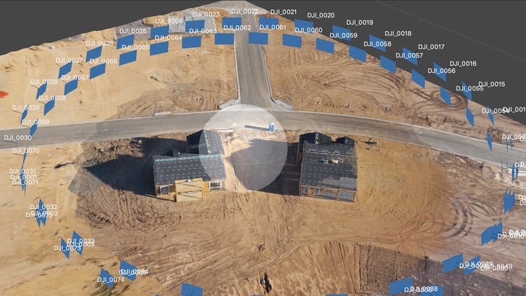
A quick model build before we dive into the details. A sneak peek at what we'll be doing in the class! And I've included images used to create this model for your use as you follow along in the course. This quick model build will show part of the overall workflow with images shot with the intent of building a simple 3D Model from a drone orbit around 2 new homes. The model isn't perfect, but it's a workable example. Hopefully this exercise will get students excited about the possibilities of modeling with drones!
-
4Drone Data Collection Apps Overview - Drone Deploy, Pix4D, Map Pilot, GS Pro...
Before we can generate a 2D or 3D model we need to capture some data (images). There are a variety of Drone capture applications on the market, and each app has it's pluses and minuses. We'll be talking about the capture apps over the next few lectures, and I'll leave it to you to decide on which one will work best for your work.
-
5Map Pilot from Maps Made Easy. Setting up for an automated modeling flight
Map Pilot is a personal favorite application when it comes to Drone Mapping and Modeling. The newest version boasts many improvements, and utilities for drone pilots looking to fine tune their image capturing process.
-
6Pix4D Capture & Drone Deploy - Capture Apps for modeling - Cloud & desktop
Pix4D and Drone Deploy also offer drone image capture applications for modeling. Both apps help you easily setup and fly a modeling mission. We'll quickly cover these two applications and their setup. Unlike Map Pilot or Ground Station Pro, you do not have as much control over your flight settings with Pix4D Capture and Drone Deploy. Both may be a good starting point for beginners before they move on to a more customizable application.
-
7Setting up Ground Station Pro for model data capture - A full mission build
In this lecture you'll see a full setup for a flight with Ground Station Pro. GS Pro is a very narrowly focused app as it is available for iPad only (no iPhones, or Androids). If you're not an iPad owner or user, that's okay. Check out the next lecture on Map Pilot. If you have an iPad, you might find GS Pro is the perfect tool for your modeling flights. It's my personal #1 goto app for capturing images for models.
-
8Setting up Map Pilot for model data capture - A full mission build
As noted in the previous lecture, GS Pro is my #1 go to modeling app. My #2 app for 2D & 3D modeling is Map Pilot from Maps Made Easy. This lecture will walk you through setup for a modeling flight with Map Pilot.
The reason for demonstrating GS Pro & Map Pilot might not be obvious to beginners. There are many image capture apps available for drone pilots looking to generate 3D Models. There's only a handful that allow you to control many settings for your data capture. Map Pilot and GS Pro leave a lot of the major decision making to you the pilot in comparison to other capture applications. And that's why both are included in this section.
-
9A 360 Degree 3D Orbit Mission - Litchi flight and image capture
This lecture takes place outdoors at a local new home construction location. You'll get to see a 360 degree orbit mission with the Litchi App. We'll do several orbits of the structures at different heights and at different radius measurements. In total 4 unique orbits that required 131 images. The final model generated from this flight will be a good example of using Metashape's Standard edition.
This is an extremely simple model covering a small area. It's a great place to start for people new to the modeling process, and new to using Metashape Standard edition.
Please Note: At the start of this lecture there are some background noises in the audio. Wind pops occur during the first minute and a half of recording, but then dissipate. One of the challenges of recording these segments outdoors.
-
10Offloading and cataloging your model images - Kyno for keeping organized.
Students need to know up front that modeling with drones consumes a lot of drive space. Large models require many images. And students may need to go back to the original files at some point for follow up. How will students find those original images from months or maybe even years ago? In this lecture we talk about organizing images after a flight, keywords or tags, and how you can quickly and easily find what you're looking for with Kyno.
-
11Adding cameras to Metashape and generating a simple model from our Litchi flight
In this lecture we take the images acquired from our Litchi flight and turn those images into a model with Metashape Standard Edition. We import our cameras, create a dense point cloud, generate a mesh, and finally add a texture to that mesh. The final result is a passable model that could be better if weren't worried about time. The default settings and low settings in Metashape are used just for expedience. But the model can be improved by spending more time in the workflow.
-
12Exporting your model for clients or the web - A quick example from Metashape
While some students might be taking this course to better understand Drone 3 D modeling for their own fun and enjoyment, others are certainly thinking about making a career out of modeling. A big part of building a business with drones has to be the final product your clients want. How you deliver final products to your clients becomes incredibly important. In this lecture we briefly examine some of the output formats that are possible with Metashape, and also we do a simple exercise of sharing a model on the Internet with Sketchfab.
-
13Ground Station Pro Flight Setup for Metashape Pro Model
In this lecture we'll take a look at Ground Station Pro, planning a flight with GS Pro, and collecting data for a larger model that we'll be building in this section. Ground Station Pro is an iPad only autonomous flight app that has proven to be useful in a wide range of applications for Drone Modeling. If you don't have an iPad that's okay. I'd suggest using Map Pilot as a backup to GS Pro. In the following lectures in this section we'll be working with the GS Pro data for a Metashape Pro model.
Students don't need to use GS Pro in their own modeling workflow. Capture apps all do the same thing. They offer assistance in flying a specific path and regularly capturing images while following the path. So if you don't have GS Pro that's okay. Whatever modeling flight app you're using will still work with Metashape, or any other 3D modeling application as well.
-
14Importing to Metashape, aligning cameras, and creating a dense cloud
Once we've captured our images the next step is to get them loaded into our modeling software. In the case of this class, Metashape. Importing the images is the easy and quick part, and everything that follows becomes a little time consuming. Once we have the images in hand we'll go through a very straightforward process. Align the photos (cameras), generate a dense point cloud, generate a mesh, and finally generate a texture for the model. We're just at the beginning here!
-
15Adding your Mesh, Texture, DEM, and Orthomosaic
In this lecture we're going to take a look at adding our Mesh, Texture, DEM, and Orthomosaic to the model. Pay close attention here. The model was rendered on Metashape Pro on a Windows 10 system, and then used on my iMac for recording purposed. That means you can render models on one OS and be able to use them on another OS. Very convenient if you need to swap between Windows and Mac.
-
16What can you export and share from Metashape Pro?
Building drone 2D & 3D models is all well and good. And it can be an enjoyable hobby. But if you're interested in doing modeling as more than a hobby, and looking to integrate modeling into your Drone business, you'll need to keep one thing in mind. The information you collect needs to be usable for your clients. That means you need to be certain that you'll be able to export data into a format your customers can use. Metashape Pro offers many export features that cover applications your customers will most likely be using.
-
17An overview of the Metashape application - Starting more advanced topics
Agisoft Metashape is well known as a higher end 3D Modeling application that works well for drone pilots. Both the Standard and Pro versions offer a lot to drone pilots looking to make both 2 and 3D models. Whichever application you decide to use you'll find Metashape offers a lot of powerful tools.
The standard workflow is straight forward. Capture your images, import to Metashape (or other 3D Modeling applications), align the photos, generate a dense point cloud, generate a 3D mesh, and add texture to that mesh. Each application has their own unique layouts and additional tools, and in this lecture we start looking at all of the tools that add to the overall workflow.
-
18A closer look at Metashape's Workflow - Align, Dense Cloud, Mesh, & Texture
For drone pilot who is a novice to 2 & 3D modeling, the initial presets offered by Metashape will still allow you to generate interesting models. Not perfected models, but good enough to hit the "wow factor" for people seeing your models. Of course, when you start doing modeling work for clients you'll probably want to step up your game.
Metashape offers a host of tools for refining your models. In this lecture we'll talk about the workflow, and using settings beyond the defaults.
-
19Model manipulation - Trim your model area before generating clouds, meshes, etc
Model areas are first defined when using your image capture application. Sometimes our models will have unrefined edges, information outside of the capture area we're interested in, and potentially mistakes within our photo set.
One of the powerful features of Metashape is the fact that we can manipulate and trim our models before our final renders. Maybe our point cloud has features outside of our area of interest. We can trim the original area, helping us to avoid processing data that's unnecessary.
-
20Metashape's workspace arrangement and use - "What does this button do?"
Metashape offers a lot of tools as we've noted. It also offers a very customizable layout. With multiple panel support users can view their capture images, workspace chunks, jobs currently running, and more. As you advance in your modeling skills you'll find that Metashape's features will advance with you.
-
21Chunks, Batch Processing, & Camera Optimization. A few advanced topics.
Metashape has "chunks." What are chunks? You can also manually align images in Metashape. Why would you do that? Batch processing is available as well. These are a few of the advanced topics we'll introduce in this section. The steep learning curve from intermediate level drone modeling to professional drone modeling starts here.
While this is not intended to be an advanced class, I feel it's useful to include an over view of the direction you're going in with your drone modeling. The topics introduced in this section will require further research on your part. And if you're interested in learning more about the advanced topics let me know. If there's enough demand we'll see about making a new class on advanced drone modeling.
-
22Good models gone bad - Manual image alignment with Metashape can help.
In this lecture we'll take a look at a very poor quality model. Often if you make mistakes in your flight and image capture the model should be scrapped. But there are ways to improve a poor quality model. In the case of this example I would opt to reshoot the entire location, and the model really is a mess. But this messy model will help students learn about manually aligning images in Metashape to improve the overall model quality. Happy accidents to be sure, I didn't even mean to make a bad model!
-
23Ground Control Points (GCPs). GIS knowledge will be needed.
If you've done any research on Drone Modeling prior to taking this class I'm sure you've heard of GCPs (Ground Control Points). Getting your models as accurate as possible can be achieved with Metashape and many other modeling programs. But a deeper understanding of modeling and mapping will be needed to really understand how ground control points work.
This lecture and the following lecture cover the basics of what GCPs are, and how you can add GCPs to your Metashape model. But I'll be leaving a lot to students to learn outside of this course. I strongly recomend that if you're looking into high end modeling as a profession that you spend some time learning all you can about GIS and land surveying techniques.
-
24Final thoughts on GCPs and the necessary GIS knowledge needed for drone modelers
As noted in the previous lecture, GCPs are "next level" in your modeling growth. We'll talk about exporting our camera data, and importing GCP data (at a very abstract level). Creating GCPs that add value to your modeling efforts will require a lot more knowledge about GIS that we can cover in this course. You'll get the general concepts in this lecture, and we'll leave it to you to grow from there.


Social Network